How RF Location Tracking Works
RF location tracking uses radio signals to identify or estimate the location of a person, asset, or device. A transmitter or tag sends a signal, fixed receivers detect it, and software converts the collected signal data into a location.
This process may sound simple. However, reliable indoor location tracking depends on the technology, building design, antenna placement, and method used to calculate location. These factors become critical in correctional facilities, behavioral health centers, forensic hospitals, and other secure environments where walls, floors, doors, equipment, and restricted areas affect RF signals.
What Is RF Location Tracking?
RF stands for radio frequency. Radio frequency tracking uses electromagnetic radio waves to communicate between devices.
In a typical system, a person or asset carries an RF tag or transmitter. Readers, locators, anchors, or receivers installed around the facility detect signals from that device. A positioning engine then processes the signal data and reports the tag’s estimated location.
RF tracking can support several functions:
- Identifying an item at a checkpoint
- Confirming that a person has entered or left a zone
- Locating staff during a duress event
- Tracking equipment between rooms
- Recording movement through a facility
- Triggering alerts when defined rules are broken
Identification and location are not the same. A passive radio-frequency identification (RFID) reader at a doorway may confirm that a tagged item passed through that doorway. A real-time locating system, or RTLS, can provide continuous location information across a wider area.
RF tracking terms explained
| Term | Meaning |
|---|---|
| RFID | Radio Frequency Identification. A reader detects and identifies an RFID tag, usually at a fixed point or via a handheld reader. |
| RF beacon ot tag | A device that sends a radio signal at set intervals. |
| RF geolocation | The process of calculating the position of an RF signal source. |
| RTLS | A real-time locating system that tracks people, assets, or devices within a defined environment. |
| GPS | A satellite-based location system used mainly for outdoor, wide-area positioning. Requires line-of-sight to the sky. |
| RF tracker | A general term for a tag, beacon, or transmitter used within an RF location system. |
RFID may form part of an RTLS, but the terms are not interchangeable. RFID often focuses on identification or checkpoint detection. RTLS focuses on determining where something is within a defined area.
How RF Location Tracking Works: The Basic Process
Most RF location systems follow five stages.
1. A tag sends or reflects a signal
An active tag uses a battery to transmit a radio signal. It may send signals at regular intervals, when it moves, or when a user presses an alarm button.
A passive RFID tag does not normally contain its own power source. It reflects energy received from an RFID reader. This makes passive tags suitable for identification and short-range asset tracking, but less suitable for continuous, facility-wide location.
2. Fixed devices detect the signal
Readers, receivers, anchors, sensors, or locators detect the transmission. Their names vary by system, but their role remains similar: they capture information about the signal and its source.
A facility may use directional antennas to limit reception to a defined area. Omnidirectional antennas receive signals from a wider field.
3. The system measures signal properties
The system records one or more measurements, such as:
- Signal strength
- Signal arrival time
- Difference in arrival time between receivers
- Direction or angle of arrival
- Known proximity to a locator
The selected RF location technology determines which measurements the system uses.
4. Software estimates the location
A location engine compares the measurements with the known positions of the fixed devices. It may calculate coordinates, select the most likely room, or assign the tag to a defined zone.
Not every application requires an exact point on a map. During a staff duress incident, knowing the correct room, corridor section, stairwell, or secure zone may provide more operational value than reporting coordinates within that space.
5. The system displays the result or triggers an action
Location software can show the person or asset on a map, record an event, send a notification, or pass the data to another system.
The complete workflow can be summarized as:
Tag or transmitter → locator or receiver → gateway → location engine → dashboard, alert, or connected system
Key Components of an RF Location System
Tags and transmitters
Tags attach to people, equipment, keys, carts, or other assets. Their design depends on the application.
A staff safety tag may include a duress button, pull cord, person-down sensor, or tamper alert. An equipment tag may focus on battery life, attachment method, movement detection, or resistance to impact and cleaning products.
Locators, readers, receivers, and anchors
These fixed devices detect tag signals. Their number and position affect coverage and location accuracy.
In a secure facility, system designers may place locators around:
- Cells and housing units
- Treatment rooms
- Corridors
- Control points
- Stairwells
- Staff stations
- Sally ports
- Outdoor yards
- Restricted zones
The installation must control how signals cross doors, walls, floors, and neighboring rooms.
Gateways
Gateways move data from the RF network into the location software. Depending on the system, they may receive data directly from tags or collect it from locators.
Location software
The software converts RF events into useful information. It may provide maps, alarm management, location history, device status, battery alerts, reports, system health information, and integrations with security or operational systems.
How RF Systems Calculate Location
RF systems use several methods to estimate position. Some systems combine more than one method.
Proximity
Proximity systems assign a tag to the locator or zone that detected it under defined conditions. This method can provide dependable room-level or zone-level location when the infrastructure has been designed for the building.
Received Signal Strength Indicator
Received Signal Strength Indicator, or RSSI, measures the strength of the signal received from a tag. In general, a stronger signal suggests that the tag is closer to the receiver.
However, walls, metal, people, equipment, antenna direction, and reflected signals can change signal strength. RSSI therefore requires calibration and careful installation. Fine-tuned RSSI can work well for zone-based positioning, but raw signal strength alone does not always provide a reliable distance measurement.
Ranging and trilateration
Ranging estimates the distance between a tag and several fixed anchors. Trilateration uses those estimated distances to calculate a position.
Three distance measurements can estimate a two-dimensional location. Additional measurements may support three-dimensional location, fault checking, or improved accuracy.
Triangulation and angle of arrival
Triangulation estimates location using the direction from which a signal arrives. Angle of arrival, or AoA, systems may use antenna arrays to measure that direction.
A phased array uses several antenna elements to analyze the signal’s angle. The system compares angles from different points to estimate the RF emitter’s location.
Time of arrival
Time of arrival, or ToA, calculates distance from the time a signal takes to travel between devices. It requires accurate timing because radio waves travel close to the speed of light.
Time difference of arrival
Time difference of arrival, or TDoA, compares when the same signal reaches multiple receivers. The system uses the difference to estimate the source position.
These time-based methods can provide high accuracy, but they often require synchronized infrastructure, sufficient anchor density, and control of multipath effects.
RF Tracking vs GPS Tracking
GPS and local RF tracking solve different location problems.
| Factor | RF location tracking | GPS tracking |
|---|---|---|
| Signal source | Local tags, beacons, readers, and anchors | Satellites |
| Main environment | Indoor or defined local area | Outdoor and wide-area |
| Building performance | Designed for indoor coverage | Often weak or unavailable indoors |
| Infrastructure | Requires local RF devices | Requires satellite reception |
| Typical output | Room, zone, proximity, or coordinates | Geographic coordinates |
| Common uses | Staff safety, asset tracking, access events, workflow monitoring | Vehicles, fleets, outdoor workers, transport |
| Accuracy | Depends on technology and deployment | Depends on satellite visibility and receiver conditions |
People often seek an indoor system that works like GPS. However, indoor location presents a different technical problem. Satellite signals become weak inside buildings, while local RF infrastructure can be designed around the facility’s rooms, zones, walls, and operating risks.
A hybrid solution may use GPS outdoors and local RF technology indoors when an asset or person moves between both environments.
Types of RF Location Tracking Technology
Passive RFID
Passive RFID works well for identification at close range. Common uses include inventory control, access points, document tracking, and tool management.
It does not normally provide continuous real-time location without a dense network of readers.
Active RFID and RF beacons
Active tags contain batteries and transmit signals over longer distances. They can support real-time asset tracking, staff duress, movement records, and zone monitoring.
Common frequency bands include 433 MHz, 900 MHz, and 2.4 GHz. Each band behaves differently in relation to range, data capacity, antenna size, and penetration through building materials.
Bluetooth Low Energy
Bluetooth Low Energy, or BLE, commonly operates at 2.4 GHz. BLE beacons can support indoor positioning and proximity detection. Performance depends on receiver placement, beacon density, calibration, and the effect of walls and reflected signals.
Ultra-wideband
Ultra-wideband, or UWB, uses short radio pulses across a wide frequency range. It can provide precise ranging under suitable conditions. Deployments may require more anchors and careful management of non-line-of-sight conditions.
Wi-Fi positioning
Wi-Fi positioning uses wireless access points and connected devices to estimate location. It can reduce the need for separate infrastructure in some buildings, but results depend on the design and load of the Wi-Fi network.
A safety system that depends on a shared network must account for coverage gaps, network changes, traffic, security rules, and competing operational demands.
LoRa and LoRaWAN
LoRa provides long-range, low-power communication. LoRaWAN defines a network protocol for devices that use LoRa radio technology.
LoRa can carry data across large sites and through dense structures. It is generally better suited to communication and event transmission than to calculating a precise position by itself. A system can therefore combine LoRa with a shorter-range technology that determines the room or zone.
What Affects RF Tracking Range and Accuracy?
There is no single answer to how far an RF tracker can work. Published range figures normally describe tests under specific conditions, not guaranteed performance in every building.
The main variables include:
Frequency band
Lower-frequency signals often travel farther and penetrate dense materials more effectively than higher-frequency signals. Higher-frequency technologies may support more precise short-range measurements or higher data rates.
Transmit power and receiver sensitivity
A tag with more transmit power may reach receivers at a greater distance, while a sensitive receiver can detect weaker signals. Higher transmit power can reduce battery life and may increase signal overlap between zones.
Antenna type and placement
Antenna gain, direction, mounting height, angle, and surrounding materials affect the detection area. Directional antennas can help define doors, corridors, and room boundaries. Omnidirectional antennas support wider coverage.
Building materials
Reinforced concrete, steel doors, wire mesh, mechanical systems, elevators, and medical equipment can block, absorb, reflect, or redirect signals.
Thin walls create a different problem. Signals may pass through several rooms, making a tag appear to be in the wrong zone unless the system controls detection range and antenna direction.
Multipath
Multipath occurs when a radio signal reflects from surfaces and reaches a receiver by several paths. These reflections can change signal strength, direction, and arrival time.
Interference
Other radio devices may operate in the same or nearby frequency bands. A site survey should identify potential sources of interference and determine how the system will operate alongside existing networks.
Infrastructure density and calibration
More anchors or locators can improve coverage, but adding hardware without a clear design can create overlap and conflicting measurements. Effective deployment depends on placing the right devices in the right positions and calibrating them for the facility.
RF Tracking in Secure and Complex Facilities
Correctional facilities, behavioral health centers, and forensic hospitals create conditions that general-purpose indoor tracking systems may not address.
These buildings often include thick concrete walls, steel doors, secure corridors, several floors, enclosed stairwells, controlled movement routes, and areas without clear lines of sight. A staff alarm must reach the system promptly, while its location must be precise enough to guide responders to the correct place.
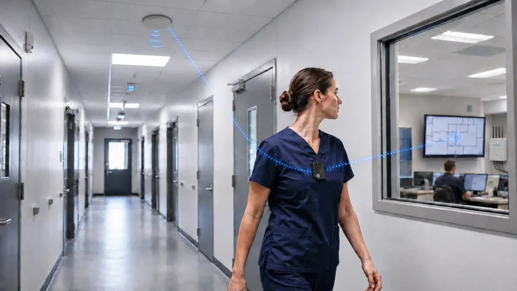
Actall’s ATLAS platform addresses these two requirements through a dual-band RF architecture.
ATLAS uses short 2.4 GHz transmissions between tags and nearby locators to determine a sub-room, room, or zone-based location. It then uses 900 MHz LoRa communication to move data between system components and gateways across the facility.
This design separates the location task from the long-range communication task. The shorter-range signal supports location precision, while the lower-frequency LoRa channel supports communication through dense construction and across multi-floor environments.
The system uses dedicated RF infrastructure rather than relying on the facility’s existing Wi-Fi network. Actall engineers configure locator density, antenna direction, detection range, and system coverage around each facility’s layout and operational requirements.
Potential applications include:
- Staff duress alerts with location context
- Officer safety in correctional housing units
- Staff protection in behavioral and forensic healthcare
- Patient, resident, or inmate movement monitoring where policy permits
- Equipment and asset location
- Entry and exit events for controlled zones
- Guard tour verification
- Workflow and response analysis
Privacy, Security, and Deployment Considerations
An RF tracking project should begin with a defined operational purpose. Organizations should document who will be tracked, why location data is needed, how long records will be retained, and who can access them.
Staff location systems should support safety and operational needs rather than collect data without clear limits. Policies, employee communication, labor requirements, healthcare privacy rules, procurement standards, and local law may affect system design.
Technical planning should also cover:
- Data access and user permissions
- Cybersecurity and network separation
- Battery inspection and replacement
- Device supervision and maintenance
- Alarm escalation procedures
- Integration with control-room systems
- Testing under normal and emergency conditions
- Coverage reviews after structural changes
A location system is only useful when staff trust the data and know how to act on it. Training, maintenance, testing, and response procedures therefore matter as much as the RF technology.
When Should You Use RF Location Tracking?
RF location tracking is a strong option when an organization needs to locate people or assets inside a building, across a defined campus, or within operating zones where GPS cannot provide dependable information.
The technology should match the required outcome. Passive RFID may be enough to identify equipment at a doorway. UWB may suit a use case that requires coordinate-level accuracy in an open area. A hybrid, dual-band system may provide a better fit when a facility needs both precise room or zone information and dependable communication through concrete, steel, and several floors.
Secure environments require more than selecting a frequency or buying tags. The system must be designed around the building, the required response, and the consequences of incorrect or delayed location data.
Actall has developed RTLS and staff safety systems for correctional, behavioral health, forensic healthcare, and other complex facilities since 1997. ATLAS combines dedicated RF infrastructure, dual-band communication, location processing, and facility-specific engineering to provide dependable indoor location information where standard approaches may struggle.
Frequently Asked Questions
How does RF location tracking work?
A tag or transmitter sends a radio signal. Fixed receivers or locators detect the signal and measure properties such as proximity, strength, direction, or arrival time. Software processes those measurements and estimates the tag’s location.
How accurate is RF tracking?
Accuracy ranges from general presence detection to sub-room positioning. The result depends on the RF technology, building materials, antenna placement, receiver density, calibration, interference, and whether the system uses proximity, RSSI, time, angle, or ranging measurements.
How far can an RF tracker transmit?
Range can vary from a few inches for some passive RFID applications to hundreds of feet or more for active RF and LoRa systems. Walls, floors, metal, transmitter power, receiver sensitivity, antenna design, and interference affect the working range.
Does RF tracking work through walls?
Some RF signals can pass through walls, but building materials reduce or distort them. Lower frequencies often penetrate dense materials better than higher frequencies. A system must balance signal penetration with the need to prevent signals from bleeding into the wrong room or zone.
Is RF tracking the same as GPS?
No. GPS uses satellite signals and works best outdoors. RF location systems use local transmitters, receivers, and anchors and can be designed for indoor rooms, zones, and secure buildings.
Can RF tracking work without Wi-Fi?
Yes. An RF location system can operate through dedicated readers, locators, gateways, and radio channels. Actall ATLAS uses its own dual-band RF infrastructure and does not depend on expanding or loading the facility’s Wi-Fi network.